
Topics
Mobility of land and people
Geographical Research in North-East India
corresponding fieldwork : Bokakhat
text and illustrations by Joëlle Smadja
Surrounded by Nepal, Bhutan, China, Burma and Bangladesh, North-East India is linked to the rest of India by a narrow stretch of land (between Nepal and Bangladesh) only thirty or so kilometres wide. This well individualised entity can be considered as an enclave whose isolation intensified in 1947 due to partition between India and Bangladesh. It corresponds to the almost closed watershed of the middle course of the Brahmaputra River. For centuries now, the river's large flood plain has been devoted to rice cultivation and, since colonisation by the British, to tea cultivation in gardens. To the North, the plain is surrounded by the Himalayan Mountains and to the south by those of the old Gondwana massif on the slopes of which, in both places, farmers practise swidden cultivation called jhum. As a territory forbidden to foreigners up until 1995, North-East India (including the states of Arunachal Pradesh, Assam, Meghalaya, Nagaland, Manipur, Mizoram, Tripura and, since 2005, Sikkim) has not been taken into consideration within Himalayan studies or by Indianists. However, thanks to its localisation, at the junction between Gangetic India, South-East Asia and Tibet, and to its diversity and complexity, it is of great scientific interest and constitutes an exceptional geographic, anthropologic and linguistic observatory.

* Geography fieldwork
The French researchers involved in this programme are Dr. Joëlle Smadja (coordination), Dr. Blandine Ripert and Dr. Tristan Bruslé. A French student ("Master 2"), Emilie Crémin, has also made some contributions. The Indian colleagues involved are Dr. Anup Saikia who teaches at Gauhati University as well as his students, and Bikash Bharali and Uttam Saikia who are our local coordinators in Bokakhat.
The geographers concentrate their work on three specificities of the region as identified during a first field trip: the high mobility of the milieux and men, the ephemeral aspect of land in the Brahmaputra plain and some communities' compartmentalization in terms of space. More particularly, they examine events that enable us to understand these specificities. These are often the result of violent upheavals, both political (partition between India and Bangladesh in 1947, autonomist movements, extension or setting up of protected areas) as well as natural phenomena on different scales (seism, seasonal events such as flash floods and flooding). Indeed, as the most seismic region in Asia, North-East India is also the rainiest and, with more than 12 metres of rainfall a year in the Meghalaya, it holds the world record for rainfall. As regards the recent past, one of the events which seems to determine territorial restructurings and habitat distribution is the 1950 earthquake along with the Brahmaputra floods which followed over a period of two years. Consequently, numerous villages disappeared or were relocated, while populations were displaced. More regularly, over the course of annual floods, the Brahmaputra and its tributaries shift in their beds, flooding old fields and uncovering new ones which are quickly occupied by needy populations in order to cultivate cereals or vegetables until they are flooded again. Such land, called sapori, is the object of conflicts between cultivators, or with the administration of natural parks.
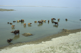
During the dry season, the saporis, ephemeral islands on the Brahmaputra
riverbed,
are mainly devoted to grazing. Milk is collected daily from one island to the other.

Rice cultivation on sapori, on the Brahmaputra riverbed
Accessing land is a crucial issue in the region: the population density, from 10/km2 in Arunachal to nearly 500 in Assam and over 1,000 in neighbouring Bangladesh speaks for itself. It explains the migration of the Bangladeshi towards the north. In order to curb the different flows, barriers have been erected: dikes have been built on the border of the Brahmaputra as well as a wall, first started in 1985, which runs the length of the border with Bangladesh...
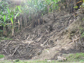
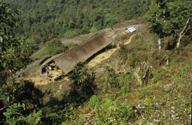
Mobility is also inherent in the way of life in the hills, dominated by shifting cultivation (jhum). This is regulated by religious and social practices specific to the region. Indian government agencies are now working to proscribe it in favour of fixed cultivation and irrigated terraces, a shift with significant environmental, economic, and social consequences.

Nyishi village and jhum in East Kameng district in Arunachal Pradesh

Nyishi village and house in East Kameng district in Arunachal Pradesh
Finally, in this area, communities are confronted with a wide variety of legislation, as is the case, for instance, of forest regulations which may differ from state to state and from place to place. Moreover, the very numerous groups of population often have a specific legal status, which is the case of the Rabhas in the "forest villages"; of the "tea tribes" in the tea gardens, separate worlds living according to their own regulations; of the Karbis, in the Karbi Anglong district and of the Khasi in Meghalaya, whose lands, exploited by shifting cultivation are, in both cases, forbidden to members of other groups; and of the Adis, Nyishis, Akas etc. of Arunachal Pradesh.
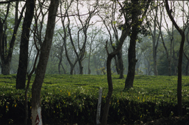
Tea garden in Assam
Part of our research is devoted to the characterization of the different territories and to their evolution, to their specificity in the Indian world and more particularly in the Himalayas. We will study the extent to which ethnic revivalism and particularist demands appear in reaction to modern conditions of pressure on land, folklorisation, the beginning of tourism, and mass Christianisation.
Particular attention shall be given to the vocabulary of agrarian practices, of techniques, and of the environment. What is shared across groups? What is communicated from group to group, and in which language? For instance, what are the territorial, social, cultural and linguistic changes due to the recent introduction of irrigated rice cultivation on the lower slopes of Arunachal Pradesh? Given that tribes, who have never practised this type of cultivation, call upon workers from the Assamese plain who come to the mountain with their own tools ... and their own technical vocabulary.


Fields devoted to swidden cultivation (jhum) are progressively converted into permanent terraced paddy fields.
In geography, this research falls within the scope of studies on territorial restructurings in the Himalayas as a whole, and within more general studies related to the consequences of environment conservation policies in very densely populated rural areas.